September 24, 2010
Threre's no need to tout the trout fishing on Arkansas' famous White River, but we can give you a better idea of how to fish it. (July 2007)
By Steve Taylor
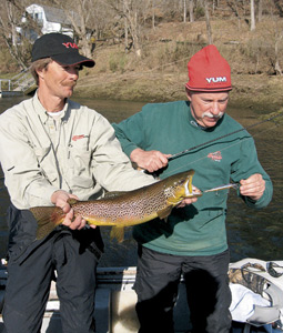 This handsome brown trout chased down Vic Attardo's Smithwick Rogue jerkbait while guide Jon Miller maintained a perfect drift on the Bull Shoals Tailwater. Photo by Steve Taylor. |
Trout fishing on the White River below Bull Shoals Dam in north Arkansas is so good that many guides fearlessly guarantee you'll catch fish. It sounds too good to be true, but this world-famous river usually keeps those promises. Folks who've never before wetted a hook routinely take limits of colorful rainbows, but the largest, wiliest fish go to anglers who understand and adapt to this challenging fishery.
This White River guide will help you cope with its notorious ups and downs, and spend more time catching fish instead of sitting in a coffee shop waiting for the water to rise or fall at your favorite hole. What follows is an overview of the river and its trout, how water moves through it, formulas for estimating when water will rise and fall and techniques to help you catch trout in the various conditions you'll encounter there.
Advertisement
WHITE RIVER OVERVIEW
The river arises in the Boston Mountains of northwest Arkansas, turns north into Missouri, then returns to the Natural State for the bulk of its 720-mile course, ending at its confluence with the Mississippi. A series of dams built between 1911 and the 1960s forms a chain of reservoirs and tailwaters in both states. This system controls flooding and provides hydroelectric power and municipal water.
Advertisement
Because the 50-degree tailwaters in the upper sections of the river were too chilly for native fish, the government mitigated their loss by stocking cold-natured trout. While the entire river fishes well, the 92-mile section between Bull Shoals Dam and Guion (Izard County) is the most spectacular, drawing anglers from across the country and abroad to catch millions of trout every year.
WHAT YOU'LL CATCH
Hatchery-reared rainbows dominate, but cutthroats, brook and brown trout spice up the mix. Pinkish-red stripes and a purplish sheen distinguish rainbows from the others. They use all parts of the river and readily take flies, lures and bait. The Arkansas Game and Fish Commission plans to stock 1.2 million rainbows that average 11 inches long and 9.6 ounces this year.
A reddish-orange slash under the jaw is a cutthroat's unmistakable field mark. Most of the 195,000 scheduled for stocking in the White this year will be caught in the coldest water near the dam. They prefer bugs and frequently fall to flies, micro-jigs and lures that imitate terrestrial insects.
Brook trout, with vividly orange fins and wormlike markings on their backs, are the dandies of the Arkansas trout clan. They, too, prefer the coldest water. The state record weighed 5 pounds, but the brookies' dazzling colors make it a pleasure to catch specimens of any size. About 12,000 11-inchers will be stocked this year.
Brown trout are the heavyweights, often measured in pounds rather than inches. These hungry carnivores chase sculpins, river minnows and jerkbaits fished near cover. The AGFC plans to put 100,000 browns in the river this year.
ACCESSES ABOVE THE NORTH FORK
Public access is excellent here, thanks to properties owned by government agencies and private trout docks, lodges and resorts. Here's a review of some -- but not all -- of the accesses on the upper half of the Bull Shoals Tailwater.
As you enter Bull Shoals-White River State Park, off state Highway 178 in the western Baxter County town of Bull Shoals, you'll see a concrete boat ramp at the AGFC's Jim Griffin Access. Slightly downstream and across the river lies a smaller ramp and walk-in access named for Ranger Boats founder Forrest L. Wood and his wife, Nina. The state park features a trout dock with boat rentals and supplies. Check out the spectacular new visitor's center, named after resort owner Jim Gaston, while you're there.
Eight miles downstream on the west (Marion County) bank, the White Hole access produces big browns. Expect more boaters than flyfishermen here, on Marion County Road 7001, a couple of miles west of Fairview.
Flyfishermen flock to Wildcat Shoals, 12 miles below the dam on the east bank. The AGFC ramp is upstream from the shoal, off Denton Ferry Road (also known as Baxter County Road 1), but navigation can be rocky in low water. Denton Ferry runs off U.S. 62/412 in Cotter.
Eighteen miles downstream at Cotter, you'll find a busy AGFC access, freshened up recently with a new ramp and rock vane for safer launching. It's on the east bank of the river in the city park off U.S. Highway 62B.
Rim Shoal has an AGFC boat ramp on the east bank, 24 miles below the dam, where fly anglers typically outnumber boats. Five-pound rainbows that cruise here prove that the nearby catch-and-release area works, but they're hard to catch. Rim Shoal is off Buford Cut-off Road near Gassville.
Four miles farther downriver on the Marion County side lies the Ranchette Access, off state Highway 101 east of Flippin. Motor upstream to the mouth of Crooked Creek, where smallmouths join the trout.
A short distance from the Buffalo City access, 32 miles below the dam in southern Baxter County, you'll find more smallmouths and trout at the mouth of the Buffalo National River. Boaters enjoy the ramp off state Highway 126 (it'll be called Buford Road, and then change to Buffalo Road at a four-way stop), but the most dedicated fly fishermen tromp along railroad tracks up to 1 1/2 miles to reach undisturbed water.
The Cartney Access, off a U.S. Forest Service road on the north edge of the Ozark National Forest in central Baxter County, is best left to adventurers willing to ford a creek. Instead, try the water at Shipp's Ferry, on Shipp's Ferry Road (Baxter County Road 61), just south of Shady Grove.
The Norfork Access, 44 miles below the dam, marks another majestic meeting of rivers. The North Fork River has even more trout per mile and empties into the White just off state Highway 5 near the Norfork community.
BELOW THE NORTH FORK
Some anglers prefer the upper White River, but the influx of cold water from the Norfork Tailwater keeps the fishing red-hot for another 45 to 50 miles. Here's a look at some of the public accesses on the lower half of the White's designated trout waters.
The next ramp downstream from Norfork, recently repaved, is at Red's Landing in southeastern Baxter County
. It's off Dwelle Road (Baxter County Road 68), which runs off state Highway 5 just south of Norfork.
To reach Chesmond Ferry, 59 river miles downriver, follow the sign off state Highway 5 in Calico Rock in western Izard County. The AGFC maintains another ramp within Calico Rock's city park; follow signs off the north end of the river bridge.
Mt. Olive, 74 miles downriver, is just above the Sylamore Catch-and-Release Area. A sign along state Highway 9 between Sylamore and Melbourne indicates the road to the ramp, which is on the east bank in southwestern Izard County.
At the Sylamore access, where state highways 5, 9 and 14 converge in Izard County, the White meets Sylamore Creek. There's plenty of parking and a wide ramp, but it's not particularly comfortable for waders or bank fishermen here.
One of the AGFC's newest accesses, Roundbottom, serves Stone County. Follow the sign off state Highway 5 between Mountain View and Allison. If the trout don't cooperate, check out the free live music in Mountain View's town square.
At Guion, more than 90 miles from Bull Shoals dam, ramps serve either side of the state Highway 58 bridge. The AGFC defines Guion as the end of the trout waters, but the fish stubbornly refuse to abide by human boundaries and populate the river for several more miles. However, the farther south you go, the scarcer the trout become. Two more ramps in central Independence County's Batesville put you in reach of a few trout as the river transitions to warmwater habitat.
ESTIMATING THE UPS AND DOWNS
The amount of water stored in Bull Shoals and how the U.S. Army Corps of Engineers and Southwestern Power Administration direct its flow through the dam are the most powerful influences on the river. In a matter of hours, water may rise or fall 8 to 10 feet, and releases can start, stop or taper off at any time. The dam's eight generators output a maximum of 26,400 cubic feet of water per second.
It's impossible to make pinpoint predictions about flows, but information is available to help you plan better and safer trips on the White. You'll have to crunch a few numbers, but the math is no tougher than what it takes to buy some Vienna sausages and crackers and split a tank of gas with your fishing buddy at your favorite convenience store.
When Mike Tipton of the Northwest Arkansas Fly Fishers plans a White River trip, he uses a formula which suggests that water moves downstream 2 1/2 m.p.h. when up to three generators are in operation, 3 m.p.h. with three to six generators running, and 3.25 m.p.h. for six to eight generators. These estimates include ranges because the generators do not all have the same capacity, and they're not always run at maximum output.
Here's an example of using Tipton's formulas: Assume that five generators are running and you want to know when rising water will reach Rim Shoals, 24 miles from the dam. Divide the distance downstream in miles (24) by the mph factor for five generators (3) to arrive at an estimate of 8 hours for water to rise at Rim Shoals.
If you were fly fishing near the dam, you'd use this information to get out of the rising water safely and add several hours to your fishing day by driving to a downstream access. Or if you were fishing from a boat, you might head upriver, then follow the surging water downstream for the excellent fishing that accompanies rising water.
Other systems suggest that water moves at 5 mph with all eight generators cranking or that you can use a general factor of 3 mph for rough estimates. However, it's difficult to account for all the variables, such as rainfall and pre-release water levels.
Below the White's confluence with the North Fork, you must also consider flow from Norfork Dam, which can up the estimating factors by a couple of miles per hour. See the end of this article for information about obtaining a book from the North Arkansas Fly Fishers that contains tables to help you adjust to rising and falling water.
Eventually, the water that goes up must come down. Although the same variables apply, you can roughly estimate how many hours it takes for 90 percent of the water to fall out of a specific area, Tipton advised. Once again, determine how many miles downstream the spot is and divide by 2. For Rim Shoals, 24 miles below the dam, the water would near its pre-release level in 12 hours.
Armed with that information, a fly angler would head upstream to find shallower water, while a boater might continue fishing downstream, where stable or slowly rising water levels usually mean good fishing.
GENERATION INFORMATION
It's always wise to check water levels before you fish. Call (870) 431-5311 for Corps of Engineers recordings that describe how many generators are running, how long they've been in operation (or when the last period of generation occurred) and the current lake level.
These recordings describe flood-control and hydropower releases from Bull Shoals and Norfork dams. At Bull Shoals, 654 feet above mean sea level represents the top of the conservation pool or the lake's "normal" level. (At Norfork, normal level is 550 feet Sept.-April and 554 April-Sept.) When the lake is a foot or more above normal, you can often expect round-the-clock generation and high-water fishing tactics.
To dig into more details, follow Water Management links on the Corps' Little Rock District home page, www.swl-wc.usace.army.mil. You'll find a page with today's and yesterday's generation information, including the amount of water released each hour expressed as cubic feet per second. Each generator averages 3,300 cfs at maximum output; divide the turbine release in cfs by 3,300 to get a sense of how many generators were operating.
The SWPA, which markets hydropower from Corps dams, provides the current day's projected hydropower generation schedule and history for the last six days at www.swpa.gov. The site uses "BSD" to indicate Bull Shoals Dam. Tentative generation schedules are also available at 1-866-494-1993. These systems describe releases only for hydropower and don't include Corps flood-control releases.
FISHING TECHNIQUES
Everyone can find a comfortable way to fish on the White. For example, low water with no more than two generators at work means ideal conditions for wading anglers using spinning gear or fly rods. In steady low water, boaters anchor upstream from holes and catch fish with corn, red worms and paste or pelleted baits, such as YUM TroutKrilla. Guides also use freshly caught baitfish from the river.
As more generators go on line, conditions get tougher for wading or shorebound anglers, but higher water means fewer obstacles for boaters. "Up to five generators is ideal for fishing jerkbaits, like a (Smithwick) Rogue, out of a boat for big brown trout," said guide Donald Cranor of Gassville.
Marabou jigs alone or sweetened with a trailer such as a
3-inch YUM Dinger or Wooly Curltail are also effective in low to medium-high water. Boaters beware: You cannot safely anchor in rising water.
On bright days, Cranor and fellow Gassville guide Jon Miller recommend Rogues with a blue back, silver sides and orange belly, then switch to black-backed Rogues when clouds move in. Cast to cover along the banks with rapid, erratic retrieves. This heart-pounding style of fishing is very visual -- trout flash at your lures right up to the boat. Cranor recommends 6-pound-test, light green monofilament or clear fluorocarbon line on light spinning gear.
With seven or eight generators running, Miller resorts to heavy river rigs to bounce bait off the bottom as his boat drifts downstream. Tie a three-way swivel to your line; then, attach a bell sinker and short-shanked bait hook to the other eyes of the swivel. Worms, canned salmon eggs and sculpins are excellent baits in this situation. Crawfish are especially effective from May through the summer, when the crustaceans are most active in the river, Cranor said.
Fly-anglers fish high water from boats by lobbing weighted leaders to drift San Juan Worms or egg patterns under an indicator, Miller said. His sports also cast outsized streamers to the banks and aggressively strip them for a fly-fishing version of jerkbaiting.
FOR MORE INFORMATION
Book guide Donald Cranor at 1-866-789-6271, or check his Web site, www.whiterivertroutfishing.net. To schedule fishing dates with Jon Miller, call (870) 430-5177, or surf to www.whiteriver.net/jons/
The Wade Fisherman's Pocket Guide to the White, North Fork and Spring Rivers, which includes tables for estimating rising water, is available from the North Arkansas Fly Fishers club; their URL is www. northarkansasflyfisher.org.
Every trout angler also needs the 2007 edition of the Trout Guidebook, available free of charge at AGFC offices and tackle dealers statewide. The agency also offers a free wading safety brochure.
