September 29, 2010
The river names may be familiar, but area anglers often overlook these specific stretches that provide top notch smallie action.
by Bruce Ingram
No other state in the Northeast sports as many outstanding smallmouth rivers as West Virginia. After all, what state can claim as many nationally known rivers as the New, South Branch, Potomac and Shenandoah? Each of these four waterways hosts float trips that many anglers associate with these streams. But each of these rivers also possesses underrated excursions that offer marvelous fishing, and those getaways will be the focus of this article.
NEW RIVER: BLUESTONE DAM TO SANDSTONE FALLS
When smallmouth enthusiasts think of the New River, they often consider the part of the stream that courses through the lower New River Gorge as being a little piece of bronzeback heaven. But the 11-mile section from below Bluestone Dam to the top of Sandstone Falls receives much less fishing pressure and has much to recommend it as well. Another positive about this section is that it is much more accessible. Much of this stretch of river does not have to be fished from a raft.
Advertisement
The first leg of the journey begins several hundred yards below Bluestone Dam in Hinton. The river right put-in is at a town park known as Bellepoint, located off state Route (SR) 3. Wade-fishing is very popular here, as the water in most places is less than 4 feet deep. Water willow beds are common, and the best bass fishing action often takes place around them. However, wade-fishermen have been known to drown here when falling into deep holes. I strongly recommend that waders don life jackets; that's sound advice whether you are wet wading or in a raft.
Not far below the put-in, you will float under the SR 3 Bridge, where you'll encounter a series of small islands on river right. The left shoreline also provides good fishing as riprap lines the bank. Note also that the Greenbrier River enters on the right as you go downstream.
Advertisement
The next focal point is the SR 20 Bridge, which crosses the New about a mile below the dam. Some fine deep-water bassing exists in this area. For the next several miles, the New travels along at a pleasant clip as you leave Hinton behind and encounter fewer homes.
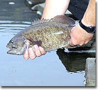 Photo by Michael Skinner |
About four miles into the Hinton getaway, you will spot the Tug Creek access point on river left off SR 26. This is an alternate take-out, especially if you do not like to run rapids. The first four miles present little challenge for the average summertime canoeist; indeed, this is one of the virtues of the upper New in West Virginia: You don't need to own a raft to enjoy this part of the stream.
However, below the Tug Creek access point, the several hundred-yard-long Tug Creek Rapid begins in the area where Tug Creek enters the river. In the summer, when water levels are normal, intermediate canoeists should be able to run this rolling Class II with little difficulty. I have found this rapid "bumpy" but not overly challenging to negotiate. However, when water levels are high, as they sometimes are after a summer thunderstorm or downpour, Tug Creek can metamorphose into a Class III. Portaging is possible on river left.
A long pool below the Tug Creek Rapid offers some superb smallmouth sport, especially if you are adept with Carolina rigs or deep-running crankbaits. The next two miles of the New send forth easy Class I rapids and riffles. The scenery is fairly pleasant as both banks are wooded in many areas, although houses occasionally dot the shorelines.
Soon, though, you will hear the roar that announces Brooks Falls, a strong Class III rapid. While in a raft, my boat mates and I have run Brooks Falls on its far right side. But canoeists and inexperienced rafters should not attempt to run this rapid; portage on river left if you plan to continue to Sandstone Falls. If you do take out, access is via a river left take-out on county Route (CR) 26 (River Road).
The float trip from below Brooks Falls to above Sandstone Falls is the mildest one on the Mountain State portion of the New, and it is ideal for boaters who do not care for major rapids. Only one Class II exists, and that one - Brooks Ledge - can be easily portaged. I recently took this 4-miler with Bill Handy, who operates Appalachian Backcountry Expeditions in Daniels. We scored by working tubebaits around deep-water dropoffs adjacent to the shoreline - a sound pattern throughout the warmwater period.
Soon after you launch from below Brooks Falls, you will come to Brooks Island, a landmass that extends for over a half-mile. Handy recommends that floaters paddle down the right side of the island because it offers deeper water. The guide says he is always amazed at how the island seems to draw wildlife. We spotted deer along the shoreline as well as Canada geese, mallards and great blue herons. Obviously, the island contains profuse amounts of rock and wood cover on both its sides, and these areas serve as holding areas for smallmouths. Also note that SR 20 parallels the river through this section.
As you drift by Brooks Island, you will occasionally encounter Class I rapids and riffles. None of these will likely be a problem, but the Class II Brooks Ledge may cause difficulty. Some local sportsmen have dubbed Brooks Ledge as "Brooks Falls II," a sharp drop does occur on the river left side of the rapid. However, boaters can avoid this rapid by portaging along Brooks Island or by drifting along the river right bank. If you are in a canoe, johnboat or similar craft, I recommend portaging. About 100 yards below Brooks Ledge, an easy Class I riffle appears in the form of a ledge. This drop in the stream bottom is fun to run.
After you leave Brooks Island behind, you will note that SR 20 has left the shoreline and been replaced by railroad tracks, which parallel the New for the rest of the float. Handy says this section has a reputation for producing huge muskies.
About a half-mile above Sandstone Falls, you will encounter a Class I rock garden. The above-surface boulders and the subsurface ledges all have the potential to hold smallmouths. After you leave the rock garden, begin looking for a place to take out on river left. (Community take-outs exist along CR 26.) You will soon hear the roar emanating from Sandstone Falls, which is not floatable. White signs warning of the imminent danger can be spotted from both banks, and in the distance, the horizon seems to "fall away." Both of these are clues that you are nearing the end of your 11-mile journey down the New River.
SHENANDOAH RIVER: RIVERSIDE TO AVON BEND
From the SR 7 low-water bridge at Castlemans Ferry to Millville, float- fishermen have some 18 1/2 miles of the main stem of the Shenandoah to enjoy. (Note: For approximately the first two miles of this section, you
will be in Virginia, and the Old Dominion and West Virginia do not have a reciprocal fishing agreement.) I would be hard-pressed to say which part of this 18 1/2-mile section could be classified as more underrated or underfished than the rest, but I would say that certainly one of the more fetching floats is from Riverside to Avon Bend. This float is one that my wife, Elaine, and I especially enjoy; in fact, we are slated to take it once again this summer.
This 4-miler begins on river left off Ann Lewis Road at Riverside. The river flows very gently at the put-in, and this is something that Elaine, who does not care for rapids, relishes. Indeed, the Riverside excursion is a marvelous one to take with a spouse or a youngster who may be interested in floating a river for the first time.
When you have paddled not quite a mile, you may be able to espy Rock Mills on river left; look for a jumble of rocks on that side. This area is also known as Rock Ferry and is near where Long Marsh Run enters on river left. The next major feature is an easy Class I rapid/riffle that occurs where the Shenandoah begins a long river left bend. Anywhere on the main stem, where a riffle or rapid punctuates the stream, be sure to work that section diligently.
Except for where the Shenandoah nears its union with the Potomac, the former flows very gently, and rapids and riffles occur only sporadically. Because of that factor, aerated water is at a premium, and smallies will stack up in this "running water" during the summer heat. After you drift through the Class I rapid/riffle, you will be in a river left bend for nearly two miles. Springs occasionally enter the Shenandoah and serve as real draws for warmwater mossybacks.
The best and most common form of bank cover, though, is in the form of standing and submerged trees along the shoreline. Standing trees, such as sycamores, provide excellent sanctuaries in the form of exposed roots. Downed trees are also great places to work subsurface baits such as plastic worms, crayfish and lizards.
Near the end of this bend, you will spot another easy Class I riffle, which basically serves as the terminus for the curve. The river flows fairly straight for a while, and Bullskin Run enters on river left. Some maps label this area as Gregorys Ford. The river left take-out is at Avon Bend, not far from the community of Kabletown. Access is via CR 25-10.
SOUTH BRANCH: FISHER BRIDGE TO OLD FIELDS BRIDGE
With the possible exception of the New River, the South Branch of the Potomac offers more well-known floats than any other stream in West Virginia. After all, what dedicated Mountain State resident has not heard of the South Branch's two special-regulations sections in Hardy and Hampshire counties, respectively, as well as such well-known sections as the Smoke Hole and The Trough? I have taken all four of these floats and am enamored with each of them.
However, a superlative afternoon getaway is from the CR 13 Fisher Bridge, where the first catch-and-release section concludes, downstream to Old Fields Bridge on CR 2 via Route 220/28. This is yet another favorite float for Elaine and me, one that we have taken with John and Arvella Zimmerer of Eagles Nest Outfitters in Petersburg.
The put-in is on river left, and the river flows fairly straight for a little less than a mile. The South Branch then takes a hard dogleg to the right in the vicinity of Moorefield. For the next several miles, the scenery is quite beautiful as you float past scattered agricultural areas and wood lots.
The fishing is consistently good throughout. Riffles, water willow beds, undercut banks, sycamore-shrouded shorelines, deep-water ledges, main-channel dropoffs -the Fisher Bridge float has all of these in abundance throughout this section. I fish all of this section hard; try 6-inch plastic worms for deep-water smallies. For some reason, red has always been my most productive color.
With less than a mile to go, you will drift by several islands. The area above and below these islands offers very worthwhile fishing. After the South Branch takes a short river right bend, you will then have only a short section to canoe until you come to the river left take-out at Old Fields. I would allot six or seven hours for this short float; the bass action can be that good.
POTOMAC RIVER: TAYLORS LANDING TO SNYDERS LANDING
The upper Potomac offers approximately 20 float trips as it flows along the border of West Virginia and Maryland and Maryland and Virginia. The West Virginia section definitely receives less fishing pressure than the part of the stream shared by Virginia and Maryland. This is primarily because that part of the stream is closest to the heavily populated Washington, D.C., area and the many bass enthusiasts who go to the river to escape city life.
A marvelous trip on the West Virginia section is from Taylors Landing to Snyders Landing (4 1/2 miles). I recently took this junket with Frank Baker, a guide for River Riders in Harpers Ferry. Although a harsh July sun beat down on us throughout the day, we consistently caught smallmouths in the 12- to 16-inch range.
The put-in is on river left on the Maryland side of the river in Washington County, just off Taylors Landing Road. Baker and I began to duel with nice fish immediately after the put-in as this float contains an awesome number of underwater ledges, riffles and easy Class I rapids, along with sycamore-shrouded banks. Rivers left and right outside bends also occur, and underwater rock cover is commonplace. As a bonus, this section also harbors good numbers of walleyes. On the float, I lost a nice marble-eye that probably went around 18 inches.
Despite the great variety of cover that the Taylors Landing float contains, if I could recommend just one kind of cover to concentrate on, it would be the ledges. Riffles and gentle Class I rapids form at the majority of these ledges, and many of them lie in 4-foot depths or slightly deeper. This deep-water habitat offers anglers an excellent chance to duel with smallies in the 15-inch-plus size range.
Early on during our float, Baker and I developed a topwater pattern around those ledges. The best surface lure that midsummer day was a 3-inch chugger in a bone color. That bait alone accounted for a half-dozen smallies over a foot long. I also had the humiliating experience of losing a bronzeback that may have measured 20 inches. That fish blew up on the chugger and threw it not long afterwards.
After the last of the riffles, you will have to paddle through a slow-moving section to reach the Snyders Landing take-out. The access point is on river left on Snyders Landing Road, which is off SR 34. Sharpsburg, Md., is the nearest city.
IF YOU GO
For guided trips on the New River, contact Bill Handy at Appalachian Backcountry Expeditions (888/642-FISH). The best source of information I have found for the entire Shenandoah system is The Shenandoah River Atlas, which can be purchased from the Virginia Canal & Navigations Society, Route 2, Box 254, Lexington, VA 24450; or call (540) 463-6777. The atlas details mile by mile what r
iver runners can expect to encounter. Another very valuable map for any West Virginia river is the West Virginia Atlas & Gazetteer, which is available from DeLorme at (207) 846-7000.
For guided trips on the Shenandoah and Potomac, contact Frank Baker at River Riders (800) 326-7238 or (304) 725-6169. For information on planning a trip to the Potomac or Shenandoah, contact the Jefferson County Convention & Visitors Bureau at (800) 848-TOUR.
For canoe rental, current fishing conditions and guided trips on the South Branch of the Potomac, contact Eagles Nest Outfitters at (304) 257-2393 or (800) CALL-WVA. For information on planning a trip to the Potomac Highlands, contact Mountain Highlands, P.O. Box 1456, Elkins, WV 26241; or www.mountainhighlands.com.
Discover even more in our monthly magazine,
and have it delivered to your door!
Subscribe to West Virginia Game & Fish
